Showing posts with label walking tour. Show all posts

Sunday, February 8, 2009

Diverting Discord in Barcelona


One of my favorite spots in the Barcelona has a rather awful sounding name, despite being a thing of beauty. I'm speaking of La Manzana de la Discordia (The Block of Discord) at Paseo de Gracia numbers 35-45. Here the dramatically clashing styles of the three great architects of Catalan Modernism are on display in buildings that stand practically side by side: Lluís Domènech i Montaner' s Lleó Morera, Josep Puig i Cadafalch's Casa Casa Amatller, and and Antoni Gaudí's Casa Battló. Directly in front of the latter is a tile with km. 0 embedded on it to mark the beginning of the European Route of Modernism, also known as the European Route of Art Nouveau.
The Barcelona Modernism Route is an itinerary that takes you through the Barcelona of Gaudí, Domènech i Montaner and Puig i Cadafalch, the architects who, together with others, made Barcelona the world capital of Modernism. This Route enables you to get to know thoroughly impressive palatial residences, amazing houses, the temple that has become a symbol of the city and a huge hospital, but it also includes humbler and more everyday buildings and items such as chemists’, shops, lampposts and benches - 115 works in all which show that Art Nouveau put down strong roots in Barcelona and today Modernism is still an art that is alive and part of life in the city.*
There is an official Modernism Route Guidebook available at Barcelona tourist offices and in many local bookstores. The book includes discount coupons for sites along the route that charge entry fees. If you aren't interested in getting the book, you can find a list of the 115 sites included on the route here, as well as a briefer list of the thirty most recommended modernist monuments here.

Discord has never been so much fun!

Chao amig@s,

Carloz

*From What is the Modernism Route?

Sunday, March 9, 2008

From modern Barcelona to an ancient Iberian village (Pueblo Iberico) Part 2


Walking uphill on Puig Castellar Ave. soon brings you to the neighborhood public market, Singuerlin, which takes it's name from the barrio. Although it is in a rather uninteresting modern building, it still boasts the usual vendors of fresh fish, meat, cheese, fruit, vegetables, nuts, bread, etc. Indeed, it's a good place to pick up items for a picnic in the wooded hills of the Serralada de Marina park above.
.
Turn left at the market on Singuerlin Street and then take a right on Catalunya Ave. to continue the steep walk through the neighborhood of apartment buildings and single family dwellings -- some ugly, some attractive, some plain. When you reach the end of Catalunya Ave. at Primavera Ave, take a left and walk until it ends at Ausias Marc Street, where you take a right until this little street ends at the intersection of Dante and Roger de Flors. Look to the left for the stairway built into hillside, which goes up to Garcilaso de la Vega Street, where you turn right. Up ahead is a little circle with a city bus shelter, but take a right on the street right before the circle -- Marcelli Calvet street. Just a few meters ahead there is a water fountain and a bench that mark the end of this little street and the beginning of one of several nature trails in the park: Torrent de Les Bruixes. (Click here for a photo taken at last October's celebration of the 20th anniversary of the trail's restoration.)
.
The path winds it's way up the hill, with markers pointing out the variety of flora and fauna native to the area. After about 30 minutes there is a wide dirt road that cuts across the trail. Here you have the choice of crossing and continuing directly up to the Iberian Village at the top of the hill, or of turning right and walking along the gradually rising road. The trail gets pretty steep from this point on, so unless you're prepared for a rather sturdy hike, take the road and follow the signs to Poblat Iberic Puig Castellar. (Although, you may want to take a short side trip to the medieval Ermita de Sant Climent that is about a 2o minute walk to the east. If so, just follow the signs there.)
.
After about another 15 minutes, you reach the entrance to the little park that holds the archaeological excavation of the Iberian Village of Puig Castellar. At the base of the excavation site a nice little area has been developed, including stone benches and a wooden deck that stretches out from the hill. This is an excellent spot for taking in the magnificent views of the Besos river, Santa Coloma de Gramenet, Badalona, Barcelona, and, of course the Mediterranean.
.
Once you walk through the gate and onto the grounds, there are several signs in Catalan, Spanish and English that cover the history of the indigenous Iberian people, outline the fortified village that was located here some 2,500 years ago, mention the archaeological discoveries made at the beginning of the 20th century and describe the preservation of the site. For example, the signs let visitors know that the remains of the village were discovered by Ferran de Segarra in 1902 and that relics from the bed are preserved in the Museum of Archeology of Catalonia in Barcelona and at the Torre Balldovina Museum in Santa Coloma de Gramenet.
.
After reading about the site, head up to the crest of the hill for a walk through the ruins. Signs in Catalan point out the remains of defensive constructions, a water system and the grid of streets, among other things. Structurally the village had an elliptical form, consisting of three longitudinal streets with lined with several structures. It is estimated that more than 200 people lived there. The village economy was based on agriculture, animal husbandry, metallurgy, textiles and trade.
.
The lower section of the town was defended by a wall of stone and clay, the remains of which are easy to spot. The dwellings, which date from the 4th and 2nd centuries BC, were small -- only one or two rooms -- and were built of granite and slate, with roofs believed to have been made of branches and mud. One has been re-built, so that visitors can look inside for a glimpse of what life around the hearth must have been like.
.
At the very top of the hill is a very simple little belvedere-like shelter for sitting and absorbing the surroundings, from the ancient at your feet, to the modern kilometers below.
.
Chao amig@s,
.
Carloz
.
P.S. The Serralada de Marina park website has a nice little walking itinerary laid out from the Balldovina Museum (which is near the center of Santa Caloma de Gramenet) to Puig Castellar.

Wednesday, August 15, 2007

From the seaside to the hillside - Part 3 (Vallvidrera)

In my opinion, Vallvidrera, which is perched on the crest of the Collserola hills above Barcelona, is one of the city's loveliest neighborhoods. To get there, I usually take the FGC from Plaza Cataluña. (FGC stands for Ferrocarrils de la Generalitat de Catalunya, which is the name of the Catalonian government railway system. Within the city, FGC trains run underground, but outside the city they climb out into the light. Barcelona's transportation system is completely integrated as far as fares and tickets go. So, a pass for the metro is also a pass for the FGC.)
.
Directly in front of Café Zurich are two entrances to the underground Metro and FGC stations. From either of these two entrances one can enter the FGC station. To get to Vallvidrera take any FGC train except the one to Av. Tibidabo. There are television screens throughout the station indicating when and from which track the next train leaves. Since there are trains leaving every few minutes, it's usually possible to hop on a train immediately. I've never had to wait more than about 5 minutes.
.
After a short ride, it is necessary to get off the train at the Peu del Funicular station and transfer to the modern little funicular that goes up to Vallvidrera. This funicular station is located in an area known as Lower Vallvidrera (Vallvidrera Inferior). The transfer is easy and fast at this little open-air station; and the ride up the hill, in metal and glass cable cars manufactured in Switzerland, offers some excellent views of the city and sea below. The best views are from the seats in the back of the car.
.
The funicular's hours are 4:30am to 12:15am weekdays and 5:30am to 12:45am weekends and public holidays. Cars run every 6 minutes on weekdays and every 10 to 15 minutes on weekends and public holidays.
.
Although one wouldn't know it from the sleekly contemporary appearance of the Peu de Funicular station and cable cars, this line has been in operation since 1906, when the rail line was extended from Sarrià to Lower Vallvidrera. It wasn't until 1998 that the funicular was converted into the totally automated system it is today.
.
There is only one stop between Lower and Upper Vallvidrera: the tiny Carretera de las Aguas (Water Road) station. At this stop it is common to see hikers and bicyclers getting out. However, I usually prefer to ride to the top and then walk down to the Carretera.
.
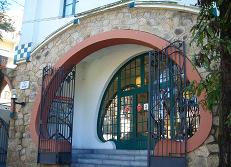
Next comes Upper Vallvidrera and a fantastic remnant of the 1906 line -- the modernist art nouveau Vallvidrera Superior station. Walking around this little jewel of a station, with its voluptuously curved windows and entrance, is like stepping back in time to the era of Gaudi. Constructed in 1905, the station was designed by the architect Bonaventura Conill i Montobbio, who who designed a good number of the buildings in Vallvidrera. Make sure to visit the viewing platform at the back of the station's lobby.
.
From here it is possible to take a city minibus (line 111) to the top of Mount Tibidabo, where a large church sits on top of an amusement park overlooking the city. Since Vallvidrera is actually surrounded by the protected Collserola Natural Park, it is also a great place to start off for a hike in the woody hills. Before doing anything else, however, get to know this quaint little neighborhood a bit.
.
The earliest known reference to Vallvidrera appeared in 987, in a document referring to the church of Santa Maria de Vallvidrera and a Gothic style church by that name was built between 1540 and 1587, and is located in what today is the park of Collserola. In the 14th century the "parish" became a "civil jurisdiction." In 1892, what was then the town of Vallvidrera was annexed by the town of Sarrià, which was then annexed by Barcelona in 1921.
.
Despite this long history, major urban development didn't begin in Vallvidrera until the second half of the 19th century, when the characteristics of the area a¡changed from that of a village to a location for summer homes of the increasingly prosperous citizens of Barcelona. A "modern" road was not built to link it with the city until 1888, when the Vallvidrera to Tibidabo roadway was constructed. In 1901 a tram was inaugurated to link Barcelona, Tibidabo and Vallvidrera. In 1906 the funicular connected the area with Sarria. At this time Vallvidrera became a popular summer residence for wealthy Barcelonans. Today it is a handsome residential neighborhood with the characteristics of a small, prosperous town.
.
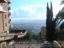
Directly across from the funicular station is Plaza Pep Ventura. Walking around the little square and the streets surrounding it, one is surrounded by superb views. Walk to one side of the plaza and gaze over the tiled roofs of lovely little houses out onto the green valley below and the Montserrat massif looming in the west. Most of the houses date to the early 1900s, as can be observed by the years inscriptions on the gables. (One house even has a Catalan poem inscribed on it!)
.
Head to the the east along C/ de Queralt, which changes from a street to a series of pedestrian steps. Look between the houses to the left for some great vies of the city. At the foot of the steps you will find the main square of the neighborhood, Plaza de Vallvidrera. Stop in at for a coffee and a sandwich at Bar Josean, which has a back sitting room with an incredible view of Barcelona and the Mediterranean. Nearby, the Can Trampa restaurant doesn't offer much of a view but is a good little spot for lunch or dinner. The plaza also hosts a modernist style wine and cheese shop, as well as a bread shop and a convenience store. One block to the north is the Mercado del Vallvidrera at C/ dels Reis Catolics 2, which sadly is set to close.
.
Walk back to Pl. Pep Ventura along C/ de les Alberes for more fantastic views of the valley leading to Montserrat. Once back at the Plaza, walk up the "street" stairs of C/ dels Algarves. More lovely houses, this time a mix of old and new, will lead you to the Hotel Vallvidrera, dating from the 1900s. Today it is a well maintained senior citizens' residence. It is easy to imagine what the place must have looked lime in its heyday.
.
At this point C/ dels Algarves rejoins C/ de les Alberes. Continue east along Alberes a bit and on the right you will find a steep "stair street" called Escales del Font del Mont carved into the side of the hill. This is one of the ways to reach the Carretera de la Aguas (Water Road) below. At the bottom of the stairs take a right on Torrent de la font del Mont and walk down until it ends at the Carretera de las Aguas. Once you reach this gravel road, head to the left and walk for about 10 minutes to find yourself in a peaceful wooded area overlooking the panorama of the city and the sea. Breathe in the fresh air, have a seat on one of the benches built alongside the road, walk through the trees above the road -- in other words, relax.
.
When you are ready to return to the buzz of the city below, head back in the direction you came, and after about a 5 minute walk beyond the entrance to Torrent de la Font del Mont, where you entered the road, you will find the Carretera de las Aguas (Water Road) funicular station. On the ride down you can enjoy one more glimpse of Barcelona stretching from the hillside to the seaside.
.
Carloz

Tuesday, August 7, 2007

From the seaside to the hillside - Part 1 (Via Laietana)


Some of my favorite routes to follow in Barcelona extend from the seafront, where I live, to the hills that surround the city. There are several to choose from, but today I will write about the beginning of a journey I regularly take, and in fact took this past weekend, with a friend: from Barceloneta up to the hills and back.
.
The first part of the journey goes from Barceloneta to Plaza Cataluña, and includes one of my favorite inner-city trajectories – traveling up Via Laietana. I initially started going this way to bypass the throngs of tourists that normally clog Las Ramblas. However, I quickly came to appreciate it for other reasons.
.
Named after the Bronze age Laietani tribes that inhabited the region, Via Laietana is a straight road that was built in 1907 to cut through the old town and link the city's seaside with the growing neighborhood called the Extension (Ensanche in Spanish; Eixample in Catalan) dating from the latter half of the previous century.
.
It is usually a very busy street, but with it's wide sidewalks, four lanes and proximity to so much history, it is a good one for a stroll or a bicycle ride. Via Laietnana is also anchored by two rather nice urban plazas: the airy Pl. Antonio Lopez at the end nearest the sea and the tree-lined Pl. Urquinaona near the city center.
.
Pl. Antonio Lopez is across from what was once the city's port and is now a yacht basin. Here you will find the striking “Correos” building – Barcelona's main post office, which was erected in 1926/27. (On one side of this building is Que Bo, the great little sandwich shop I wrote of previously.)
.
By simply walking around this square that stretches over two blocks, you can glimpse the medieval edges of the old town, structures from the 18th century, buildings from the years just before the Spanish civil war and one very bright spot from the late 20th century – Roy Liechtenstein's comic book colored “Barcelona Head” statue.
.
On the other hand, Pl. Urquinaona is a more closed-in square with many shade trees, quite a few comfortable park benches and bordered by shops, cafes, restaurants as well as by multiple Metro station entrances. (The Metro station is also known as Urquinaona. The unusual sounding name is from an Andalusian who was bishop of Barcelona in the 1800s.)
.
One of the interesting aspects of Via Laietana is its collection of early 20th century architecture -- mostly banks, government offices, guilds and other institutional buildings. The street offers a mix of styles: Art Nouveau / Modernist, Neo-Gothic, Rationalist, etc. This line up occasionally breaks open to reveal a little of Barcelona's Roman, Gothic and Medieval history just a few feet behind it.
.
At least one pre-20th century building can be found on the avenue itself. This is “Casa de Veler” at number 50, which dates from 1758. Today it is the home of the Federación Nacional de Empresarios Textiles Sederos. (National Federation of Silk Textile Employers.)
.
Right next to it, but not actually on Via Laietana, is the much more well known Palau de la Musica an incredible Art Nouveau structure dating from 1905. Today it is a UNESCO World Heritage Site, a very popular tourist attraction and an actual concert hall.
.
Back on Via Laietana, this time at number 80, you will find the impressive Caja de Pensiones building (pictured above), constructed in 1917. It looks rather cathedral-like, with it's white Neo-Gothic facade, but it is in fact home to Spain's most popular savings bank, La Caixa. A few other sites along the avenue include:
  • Pl. Antoni Maura, located at about numbers 37 and 42, is where Av. De la Catedral and Av. Francesc Cambo face each other. Despite being called “Avenues” these are actually two very spacious plazas. Av de la Catedral is the square where Barcelona's Cathedral stands; whereas Av. Francesc Cambo is a square holding a colorful and recently renovated public market, Santa Caterina;

  • Pl. Ramon Berenguer, at about number 29, has a recessed green area with a few benches tucked beneath a remnant of Barcelona's Roman wall;

  • Pl. del Angel, at about number 25, borders an ancient little street named Llibreteria, which was at one time the road that connected Barcelona and Rome.
Really, there is tons more to see on, and around, Via Laietana, so it is a great place to invest time in. Aside from all the sites and activities, it is also such a wide open street that it is a good vantage point to observe that Barcelona rises from the sea to the hills. The breadth, width and incline of the avenue combine with the grand looking architecture to provide pleasing views during a walk or a bike ride – whether it's just passing through, as I do when I head out on one of my jaunts up the into the hills, or for a more leisurely look at the obvious and not so obvious treasures along the way.
.
Well, I haven't gotten very far -- not even past the city center! -- but soon I'll tell you about the rest of one of my favorite routes to the hills.